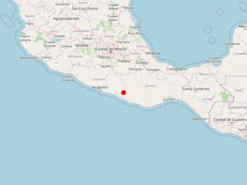
An earthquake of magnitude 2.9 occurred in the vicinity of Ometepec at 0:38 local time (6:38 UTC) today, according to the National Symological Service (SSN).
Preliminary information indicates that the epicenter of the earthquake was 17 km east of the city in the state of Guerrero and had a depth of 43 km.
Given the recent history of the telluric movement, the extent of the impact in terms of material damage and human casualties in the state of Guerrero is still unknown.
In the face of significant seismic activity, the National Center for Disaster Prevention (Cenapred) recommends not falling into rumors or false news and only reporting to official sources, such as the Civil Protection authorities, both local and state, as well as federal.
After a tremor, check your house for possible damage, use your cell phone only in case of emergency, do not light matches or candles until you make sure there is no gas leak and remember that aftershocks of the earthquake may occur, so it is important to be alert.
You can also take the following steps before an earthquake: prepare a civil protection plan, participate in evacuation drills, find safety zones at home, school or workplace, and prepare an emergency backpack.
During an earthquake stay calm and stay in a safe place, stay away from objects that may fall; if you are in a vehicle, park and stay away from buildings, trees and poles; and if you are located on the coast, stay away from the beach and take refuge in high areas.

Earthquakes in Mexico
Mexicans are used to this type of event, because the country is located in an area of high seismicity. It is worth mentioning the great damage caused by the earthquakes of 1985 and 2017, which caused great havoc throughout the Aztec territory. However, there are records of even more destructive movements in the history of this Latin American nation.
The strongest earthquake recorded in the history of what is now Mexico occurred on March 28, 1787, at the time of the Spanish colony. Its epicenter was in Oaxaca and it had a magnitude of 8.6. Not only did this make the earth vibrate incredibly, but it even caused a tsunami that reached 6 kilometers inland.
According to a study by the Center for Instrumentation and Seismic Record (Cires) carried out in 2009 on the earthquake of March 28, 1787, large earthquakes with magnitudes of 8.6 or greater could occur in the coming years. These will have as their epicenter the coasts of Mexico and Central America, because they are located in the Guerrero Breach that accumulates a large amount of energy.
However, a smaller magnitude in a seismic event does not necessarily translate into a minor impact on buildings and infrastructure. Thus, in 1985 and 2017, the inhabitants of the capital, Mexico City, had to face the devastation resulting from two earthquakes that became a water part of their lives.
On September 19, 1985, an earthquake of magnitude 8.2 occurred, with an epicenter in the state of Guerrero. It was 07:19 local time (13:19 UTC). At that time, it was thought that there would be no more earthquakes of such dimensions, but a related event occurred exactly 32 years later.
In 2017, it happened at 13:14 local time (18:30 UTC), with epicenter in an area between the states of Puebla and Morelos. Then, the death toll reached 369.
MORE NEWS
Últimas Noticias
Debanhi Escobar: they secured the motel where she was found lifeless in a cistern
Members of the Specialized Prosecutor's Office in Nuevo León secured the Nueva Castilla Motel as part of the investigations into the case

The oldest person in the world died at the age of 119
Kane Tanaka lived in Japan. She was born six months earlier than George Orwell, the same year that the Wright brothers first flew, and Marie Curie became the first woman to win a Nobel Prize

Macabre find in CDMX: they left a body bagged and tied in a taxi
The body was left in the back seats of the car. It was covered with black bags and tied with industrial tape

The eagles of America will face Manchester City in a duel of legends. Here are the details
The top Mexican football champion will play a match with Pep Guardiola's squad in the Lone Star Cup

Why is it good to bring dogs out to know the world when they are puppies
A so-called protection against the spread of diseases threatens the integral development of dogs


