The new rainy season began to have consequences in several parts of the country and that is the case in Santander. On the night of last Monday, March 14, Invias and local authorities announced the closure of the San Gil - Bucaramanga highway.
Landslides, falling trees and the overflow of a ravine in the sector known as Curos, located between kilometers 66 and 71, led the authorities to disable the important Santander road corridor.
“At this time @InviasOficial informs Santandereans that: road closure is reported due to landslides, rockfalls, trees, heavy rain and other elements,” announced last Monday night the Santander Disaster Risk Management office.
Relief agencies worked all night to enable this pathway
Invias units arrived in the Curos sector, as well as the department's relief agencies to respond to the emergency and alert citizens in order to avoid larger emergencies.
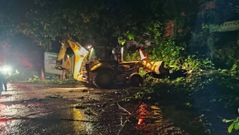
Since the heavy rain emergency occurred in the Santander Metropolitan Area, relief agencies and local authorities worked with heavy machinery to remove material that fell on the road corridor.

After these works, it was announced that a lane of the road that connects San Gil with Bucaramanga was enabled to relieve traffic congestion. However, the removal work continues.
The Bucaramanga Traffic and Transport Police assured that the restricted passage continues in the road corridor “between kilometers 64 and 71 due to the different collapses and falls of trees that occurred on the occasion of the different rains that occurred in this sector”.
“We recommend that all drivers travel with great caution; follow the instructions of the different traffic authorities and relief agencies; be on the lookout for emergency lines, social networks and media where information on the state of the road is provided,” the traffic authorities added. transport in Bucaramanga.
Red alert in municipalities of Antioquia for the rainy season
The Administrative Department of Risk Management of Antioquia (Dagran) announced, a couple of days ago, that at least 20 municipalities in Antioquia are on red alert for landslide risks, while another ten remain on orange alert to the same risk.
According to the Dagran report, the municipalities with the highest risk of landslides in the department are: Murindó, Dabeiba, Uramita, Abejorral, Concepción, El Carmen de Viboral, El Peñol, Granada, La Unión, Nariño, Sonson, Amagá, Andes, Apartadó, Carepa, Chigorodó, Mutata, Turbo, Barbosa and La Star.
Likewise, the road corridors that are on alert for the possibility of landslides are: Abejorral-Santa Bárbara; Barbosa-Concepción village Chapa Alta at kilometer 11 + 440; Uramita-Dabeiba PR 26+00 Peñas Blancas sector, and Dabeiba-Mutatá.
The departmental authorities also alerted citizens to the risks of possible sudden increases in different tributaries of the territory.
KEEP READING:
Últimas Noticias
Debanhi Escobar: they secured the motel where she was found lifeless in a cistern
Members of the Specialized Prosecutor's Office in Nuevo León secured the Nueva Castilla Motel as part of the investigations into the case

The oldest person in the world died at the age of 119
Kane Tanaka lived in Japan. She was born six months earlier than George Orwell, the same year that the Wright brothers first flew, and Marie Curie became the first woman to win a Nobel Prize

Macabre find in CDMX: they left a body bagged and tied in a taxi
The body was left in the back seats of the car. It was covered with black bags and tied with industrial tape

The eagles of America will face Manchester City in a duel of legends. Here are the details
The top Mexican football champion will play a match with Pep Guardiola's squad in the Lone Star Cup

Why is it good to bring dogs out to know the world when they are puppies
A so-called protection against the spread of diseases threatens the integral development of dogs


